Showing 327 items matching mining districts
-
 Federation University Historical Collection
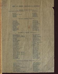
Document, List of MIning Divisions and Districts attached to the Victoria Government Gazette No. 26; February 1911, 1921
... List of MIning Divisions and Districts attached to the...mining districts... Document List of MIning Divisions and Districts attached ...Documentmining divisions, mining districts, victoria, ballarat mining district, ararart mining district, beechworth mining distrct, castlemaine mining district -
 Federation University Historical Collection
Book, American Institute of Mining Engineers, Transactions of the American Institute of Mining Engineers, Vol 1, 1871-1873
... mining districts in the United States of America... of members * Geological Distribution of MIning Districts... * Geological Distribution of MIning Districts in the United States (R.W ...Meetings of the institute were held in Wilkes-Barre, Bethlehem, Troy, Philadelphia, New York, Pittsburgh and Boston.Red hard covered book. Contents include: * List of members * Geological Distribution of MIning Districts in the United States (R.W. Raymond) * The Relation between the Speed and Effectiveness of Stamps (R.W. Raymond) * Remarks on the Waste in Coal-Mining (R. P Rothwell) * An Eccentric Theodolite (Francis Vinton) * The Use ad Advantages of the Prop Srew-Jack (E. Gaijot) * The Manufacture of Iron and Steel Rails ( John B. Pearse) * The importance of Surveying in Geology (Benjamin Smith Lyman) * Use of Blast-Furnace Slag (T. Egleston) * The Geonostical History of Metals (T. Sterry Hunt) * The Mining and Metallurgical Laboratories of the Massachusetts Institute of Technology (Robert H. Richards) Stamped "Department of Mining University of Melbourne"american institute of mining engineers, mining engineering, prop screw jack, mining districts in the united states of america, waste inn coal mining, lehigh zinc company, lake superior copper districtblast furnace, rolling versus hammering ingots, indianablack coal, pig-iron, longwall system of mining, wickersham process, midlothian colliary, virginia, plummet lamp, diamond drills -
 Federation University Historical Collection
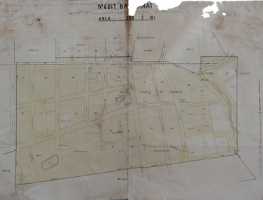
Map, No 6817 Ballaarat, Parish of Ballaarat, Mining District of Ballaarat, c1908
... No 6817 Ballaarat, Parish of Ballaarat, Mining District of...mining districts... No 6817 Ballaarat, Parish of Ballaarat, Mining District ...Printed map with pencil inscriptions on recto and versomap, mining districts, mining district of ballaarat -
 Federation University Historical Collection
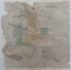
Map, Lintons Pre-emptive Section, 1872
... mining districts... shading by F. W Niven Lydiard Street, Ballarat map mining ...Printed map with coloured shading by F. W Niven Lydiard Street, Ballaratmap, mining districts, lintons claim, lintons diggings, f w niven, nivens steam lithographic machine, f.w. niven -
Federation University Historical Collection
Booklet, Report of the Board Appointed to Advise the Government as to the Best Mode of Developing the Auriferous and Mineral Resources of the Colony, 1879-80, 1880
... mining districts... mining districts ballarat mining district auriferous resources ...White Foolscap printed Government document relating Victoria's mineral resources.mineral resources, mining, mining districts, ballarat mining district, auriferous resources, william collard smith, rivett henry bland, henry rosales, robert m. sergeant, a.w. howitt, deep leads, carisbrook, sebastopol, sebastopol plateau, r.m. harvey, james m. main, john wall, g. hale, t.h. thompson, james leckie, e.h. uren, james cotter, p. matthews, w.k. peden, john sharp, g.c. robinson, dead horse lead, william benson, j. keith, smythesdale, charles thorne, haddon, linton, little bendigo, scarsdale, blackwood, daylesford, owen jones, james mcmillan, h.h. sainsbury, thomas bury -
Federation University Historical Collection
Document, Board of Science, 1859-1860
... mining districts... goldfields mining districts population statistics machinery John ...Blue Foolscap printed Government document relating to the Board of Science. science, goldfields, mining districts, population statistics, machinery -
Federation University Historical Collection
Document, Gold Fields Act Order in Council for the Divisions of the Mning District of Castlemaine, 1860-1, 1860-1861
... castlemaine mining district...Blue Foolscap printed Government document for the mining... Government document for the mining district of Castlemaine ...Blue Foolscap printed Government document for the mining district of Castlemaine.castlemaine, castlemaine mining district, goldfields act, j.h. kay, john basson humffray, fryer's creek, tarrangower, hepburn, st andrew's -
Stawell Historical Society Inc
Archive - Book, Stawell Shire, Registration Of Residence Sites 28-7-1931 - 20-6-1934, 1931
... Stawell Ararat Mining District Registration Book 12P ... on front cover Stawell Ararat Mining District Registration Book ...Residence Area Miners Right used by Stawell ShireLarge Brown Covered Leather Ledger with Label on front coverStawell Ararat Mining District Registration Book 12P local government, miners right -
Federation University Historical Collection
Document, Addiional Polling Place for Mining Ditrict of Ballaarat Order In Council under the Goldfields Act, 1863
... ballaarat mining district... an additional polling place for the Mining District of Ballaarat.... for the Mining District of Ballaarat. goldfields act j.h. kay ballaarat ...Blue Foolscap printed Government document outlinging an additional polling place for the Mining District of Ballaarat.goldfields act, j.h. kay, ballaarat mining district, ballarat, james forester sullivan -
Federation University Historical Collection
Booklet, Robert Brain, Government Printer, Mineral Statistics of Victoria for the Year 1880-1881, 1881
... flagging slates quartz mining gold districts ballarat beecworth ...White Foolscap printed Government document relating Victoria's mineral statistics.statistics, mineral statistics, h.r. williams, gold yeild, gold, silver, tin, copper, antinomy, lead, iron, coal, lignite, kaolin, flagging, slates, quartz mining, gold districts, ballarat, beecworth, bendigo, sandhurst, maryborough, castlemaine, ararat, gippsland, water rights, gunpoweder, mining companies -
 Federation University Historical Collection
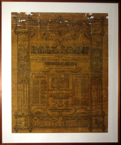
Work on paper - Artwork - Poster, Past and Present Ballarat of Forty Years of Progress from an Uninhabited Wilderness, 22/10/1892 - 17/03/1898
... to the native born children of European parents in the Ballarat Mining... to the native born children of European parents in the Ballarat Mining ...James McKain MEEK (1815-1899) Born England Arrived Australia 1838 James Meek was an artist who built the first house at Ballarat. He wrote 'designed, composed and written with pen and ink by James Meek (founder of the City). When this work was completed the in 1893 the Ballarat Star described the work: - "An Industrial Inmate. At the conclusion of Monday's meeting of the Ballarat Benevolent Asylum Committee one of the inmates, named James McBain Meek, having been introduced, laid upon the table a magnificently executed work of art, bearing the following inscription: - The past and present of Ballarat, or 40 years' progress from an uninhabited wilderness, 1852 to 1892, during which time it has become the grandest inland city of the Southern World. It stands unrivaled by that of any city in her Britannic Majesty's extensive domain over which the sun never sets, and o'er which Albion's beloved sovereign sways her benign sceptre." The work conveys by words and pictorial representations a complete history of Ballarat from its inception up to the 17th March inst. The various pillars and scrolls by which the many incidents that are related are surrounded are marvelously executed, the plain and ornamental lettering is exquisite; while the language used in the narrative is of the most eloquent and refined description. Sketches of the Ballarat Hospital and Benevolent Asylum, equal to any photographic picture, are shown at either end of the word " Ballarat," which occupies the most central position of the chart. The work, which is worthy of a position in any public library or private residence, has been designed and composed by Mr. Meek, who is 78 years of age, at the Asylum. It is done entirely with pen and ink, and was commenced on the 22nd October, 1892, and completed on 17th March, 1893. (Ballarat Star, 27 March 1893)Although 'Past and Present Ballarat of Forty Years of Progress from an Uninhabited Wilderness' was printed it appears that few have survived the ravages of time. Another copy of this works survives in the collection of the Australiana Room at the Central Highlands Regional Library Corp. No others have been located to date. (2012)Large black and white poster (now brown with age) with the hand drawn work of James Meek reproduced by the Ballarat printers Rider & Mercer. Many, but one includes 'Most respectfully dedicated to the native born children of European parents in the Ballarat Mining District by the author.'ballarat, james meek, meek, ballarat benevolent asylum, nazareth house, ballarat mayors, james bury, james oddie, la poer trench, welfare -
 Bendigo Historical Society Inc.
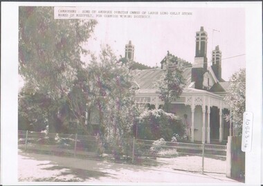
Photograph - Home of Ambrose Dunstan
... of the Long Gully store. The house is named after the Cornish Mining... is named after the Cornish Mining District. Poor photocopy of Mr ...This home "Crambourne" was designed by architect, Mr William Beebe and built around 1875 for Mr and Mrs Ambrose Dunstan, in Creeth Street, Long Gully.Cambourne, home of Ambrose Dunstan, who was owner of the Long Gully store. The house is named after the Cornish Mining District. Poor photocopy of Mr. Ambrose Dunstan, taken when he was mayor (not dated). Photocopies of originals, undated photographs.home and portrait of ambrose dunstan, ambrose dunstan mayor, cambourne, long gully -
 Ringwood and District Historical Society
Map, Department of Mines, Plan of area applied for under the mining leases regulations in the township of Ringwood between Maroondah Highway and Mt. Dandenong Road. Mining District of Castlemaine, County of Mornington, Parish of Ringwood T Area 58(A) 2 (R)15(P) Acres, Roods, Perches. 1934, 20-Feb-34
... Mt. Dandenong Road. Mining District of Castlemaine, County of... and Mt. Dandenong Road. Mining District of Castlemaine, County... between Maroondah Highway and Mt. Dandenong Road. Mining District ...Map of the township of Ringwood with subdivisions between Maroondah Highway and Mt. Dandenong Road. the area applied for on lease No.8210 by E.G.Browne.Mining District of Castlemaine, County of Mornington, Parish of Ringwood T Area 58(A) 2 (R)15(P) Acres, Roods, Perches.Buff coloured sheet foolscap with black printing showing map of the township of Ringwood between Maroondah Highway and Mt. Dandenong Road. Mining District of Castlemaine, County of Mornington, Parish of Ringwood T Area 58(A) 2 (R)15(P) Acres, Roods, Perches +Additional Keywords: Browne E.G. -
Federation University Historical Collection
Book, Australasian Institute of Mining Engineers, Transactions of the Australasian Institute of Mining Engineers, Volume X, 1905
... Stamped in red 'W.E.U. of A. Mining Department Barrier...) * The Indicators of the Daylesford Gold Mines, Victoria * Mining Accounts ...Fabric covered hardcovered book of 367 pages. Includes a number of pullout plans. Contents * Mount Lyell Mining Field Tasmania by Professor J.W. Gregory * Concentration of solver-led ores (with 6 plates) by V.F. Stanley Low * Phosphate Deposites of Ocean and Pleasnt Islands (with 15 plates) by F. Danvers Power * Coal and Coal Mining in New SoPleassant Isuth Wales by Thomas Parton * Method of TImbering at the Mount Rex Tin Mne, Ben Lomand, Tasmania by Mark Ireland * Peck's Centrifugal Elevator by W. Peck * A Portable Assay Furnace by J.J. Gillio * NOtes on Sampling by A.C. Thomas * The Career of the Gold Dredge i n New South Wales by David K. Blair * The Transmission of Power by COmpressed Air in Mines by R.W. Chapman * The Misplacement of Mning Shafts and Adits in Victoria (with 7 figures) * The Indicators of the Daylesford Gold Mines, Victoria * Mining Accounts by R.N. Kirknon-fictionausimm, a.s. kenyon, frank a. moss, mount lyell, j.w. gregory, coal, gold dredge, transmission of power, mining shaft audits, daylesford gold mines, spitzkastens, ocean island banaba, pleasant island nauru, pinnacles on flat reef pleasant island, ocean island, blow hole howe bay, rock phosphate, thomas parton, mark ireland, mount rex tin mine, ngapara dredge, w. peck, w.h. vale, daylesford, jim crow diggings, glenmona gmc, f. danvers power, leigh g. hancock, workers' industrial union of australia (barrier district) -
 The Beechworth Burke Museum
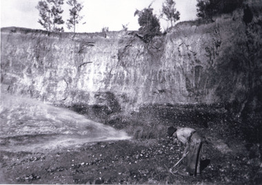
Photograph, 1920 - 1930
... mining district was one of six mining districts established... sluice boxes to remove the gold. The Beechworth mining district ...Taken between circa 1920 - 1950 this photograph depicts the open mine in the Three Mile Mine at Barramutha. The mine was an important gold resource and was typically mined using a method known as hydraulic sluicing whereby high powered water jets are used to dislodge rock or move sediment. The remaining water sediment slurry is directed through sluice boxes to remove the gold. The Beechworth mining district was one of six mining districts established by the governor-in-council on 4th of January 1858 under the provisions of An Act for Amending the Laws Relating to the Goldfields (21 Vic no. 32).This photograph shows cultural and research value into the historical methods of hydraulic sluicing in the Beechworth mining disctrict. It also shows the evolution of the mining methods and has potential for understanding future engineering endeavors in the context of victorian mine goldfields.Black and White rectangular photograph printed on matte photographic paper.Reverse: Copied from original on loan from Webb (QLD)/ Donated Nov 2009/ Barnawatha Three Mile Mine c1920-1950 Minehead & Slicing/ Managed by John Weir, Peter Jensen, Jack Cox/ Owned by/ the Plain Bros then Parkinsons/ John worked for Pqarkinsons. three mile creek, three mile goldfields, three mile beechworth, goldfields, #beechworth, hydraulic mining, hydraulic sluice, burke museum -
 The Beechworth Burke Museum
Photograph, Circa 1920 - 1950
... to remove the gold. The Beechworth mining district was one of six... to remove the gold. The Beechworth mining district was one of six ...Taken between circa 1920 - 1950 this photograph depicts a man dressed in dark trousers, a white long sleeved shirt and broad-brimmed workers hat digging around in the Three Mile Mine at Barramutha. The mine was an important gold resource and was typically mined using a method known as hydraulic sluicing whereby high powered water jets are used to dislodge rock or move sediment. The remaining water sediment slurry is directed through sluice boxes to remove the gold. The Beechworth mining district was one of six mining districts established by the governor-in-council on 4th of January 1858 under the provisions of An Act for Amending the Laws Relating to the Goldfields (21 Vic no. 32). This photograph shows historic and research value into the historical methods of hydraulic sluicing in the Beechworth mining disctrict. It also shows the evolution of the mining methods and has potential for understanding future engineering endeavors in the context of victorian mine goldfields. Black and white rectangular photograph printed on matte photographic paper.Reverse: 7597.3/ Copied from original on loan from Webb (QLD)/ Donated Nov 2009/ Barnawatha Three Mile Mine 1920-1950/ Owned by Plain Bros then Parkinsons/ Managed by John Weir, Peter Jenson, Jack Cox/ Slicing. three mile creek, three mile goldfields, three mile beechworth, goldfields, #beechworth, hydraulic mining, hydraulic sluice, burke museum -
 Marysville & District Historical Society
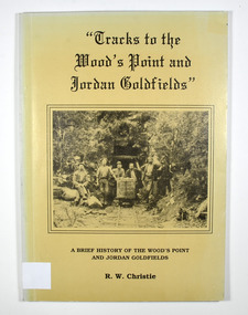
Book, Tracks to the Wood's Point and Jordan Goldfields-A brief history of the Wood's Point and Jordan Goldfields, Unknown
... the cover is a drawn map entitled 'Map of the Mining District round... of the Mining District round Wood's point'. Stamp of the Marysville ...A history of the Wood's Point and Jordan gold fieldsPaperback. Beige cover. Front cover has a black and white photograph of miners standing and sitting around a mine cart that is sitting on railway tracks at the entrance to a mine.Back cover has a cartoon drawing of a pack horse that has fallen down a cliff with his rider trying to pull him back up by his tail. Inside the cover is a drawn map entitled 'Map of the Mining District round Wood's point'.Stamp of the Marysville & District Historical Society Inc / P.O. Box 22 / Marysville 3779 gold, gold field, gold mining, gold town, wood's point, jordan goldfields, victoria, australia, history, r w christie -
 Marysville & District Historical Society
Book, Tracks to the Wood's Point and Jordan Goldfields-A brief history of the Wood's Point and Jordan Goldfields, Unknown
... the cover is a drawn map entitled 'Map of the Mining District round... of the Mining District round Wood's point'. Stamp of Marysville ...A history of the Wood's Point and Jordan gold fieldsPaperback. Beige cover. Front cover has a black and white photograph of miners standing and sitting around a mine cart that is sitting on railway tracks at the entrance to a mine.Back cover has a cartoon drawing of a pack horse that has fallen down a cliff with his rider trying to pull him back up by his tail. Inside the cover is a drawn map entitled 'Map of the Mining District round Wood's point'.Stamp of Marysville & District / Historical Society Inc / P.O. Box 22 / Marysville 3779 gold, gold field, gold mining, gold town, wood's point, jordan goldfields, victoria, australia, history, r w christie -
 The Beechworth Burke Museum
Photograph
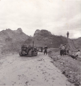
... Beechworth Mining District... the Beechworth Mining District. These were cut through solid rock... constructed throughout the Beechworth Mining District. These were cut ...The photograph depicts a mine cut with a tractor. Water is being used to sluice the front of the tractor, possibly to separate any gold that may have been picked up from the earth. A few people watch the demonstration. Water was a significant part of gold mining in the Beechworth area and miners used a method known as 'hydraulic sluicing'. Due to the amount of water required, many water races were constructed throughout the Beechworth Mining District. These were cut through solid rock and are an example of engineering achievement. Water usage in the area put Beechworth at the heart of water policy, with many firsts for Victorian colonial goldfield water management being established in the Beechworth Mining District. This photograph is significant as it depicts the use of water in gold mining in Beechworth. Beechworth was notable for it's use of water in mining.Black and white square photograph (portrait orientation) printed on matte photographic paper.Reverse: SW-50-2 / 1997 31136 / unreadable pencil markingssluicing, gold mining, mining, hydraulic sluice, hydraulic sluicing, beechworth mining district -
 The Beechworth Burke Museum
Photograph, 1920 - 1930
... mining district was one of six mining districts established... mining district was one of six mining districts established ...Taken between circa 1920 - 1930 this photograph depicts a Hydraulic water jet in the foreground and a man dressed in dark trousers, a white long sleeved shirt and broad-brimmed workers hat digging around in the Three Mile Mine at Barramutha. The mine was an important gold resource and was typically mined using a method known as hydraulic sluicing whereby high powered water jets are used to dislodge rock or move sediment. The remaining water sediment slurry is directed through sluice boxes to remove the gold. The Beechworth mining district was one of six mining districts established by the governor-in-council on 4th of January 1858 under the provisions of An Act for Amending the Laws Relating to the Goldfields (21 Vic no. 32).This photograph shows cultural and research value into the historical methods of hydraulic sluicing in the Beechworth mining disctrict. It also shows the evolution of the mining methods and has potential for understanding future engineering endeavors in the context of victorian mine goldfields.Black and White rectangular photograph printed on matte photographic paper. Reverse: Copied from original on loan from Webb (QLD)/ Donated Nov 2009/ Barnawatha Three Mile Mine c1920-1950/ Owned by Plain Bros then Parkinsons/ Managed by John Weir, Peter Jenson, Jack Cox/ Slicing. three mile creek, three mile goldfields, three mile beechworth, goldfields, #beechworth, hydraulic mining, hydraulic sluice, burke museum -
 The Beechworth Burke Museum
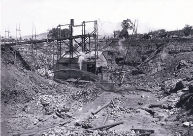
Photograph, c1920
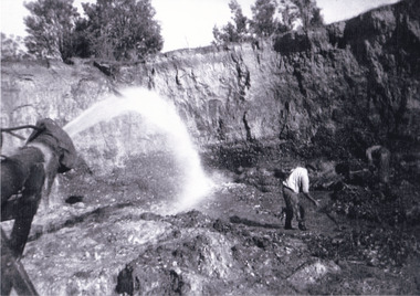
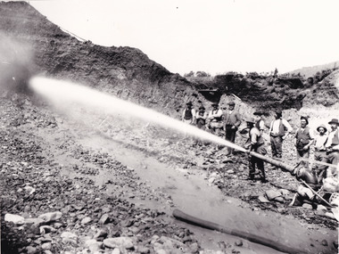
... , Beechworth . The Beechworth Mining District was one of six mining... District was one of six mining districts established ...This photo shows the large mining cavity with a hydraulic sluicing machine in operation at Baarmutha Three Mile Mine, Beechworth . The Beechworth Mining District was one of six mining districts established by the Governor-in-Council on 4 January 1858 under the provisions of An Act for Amending the Laws Relating to the Goldfields (21 Vic no.32). The District was further divided into seven divisions: Spring Creek, Snake Valley, Three Mile Creek, Buckland, Woolshed, Yackandandah and Omeo. The boundaries of each of these divisions and of the whole district are described in the Governor-in-Council's proclamation printed in the Government Gazette, 5 January 1858, pages 3-5. Hydraulic mining is a form of mining that uses high-pressure jets of water to dislodge rock material or move sediment. In the placer mining of gold or tin, the resulting water-sediment slurry is directed through sluice boxes to remove the gold. It is also used in mining kaolin and coal.This photograph shows the impact the gold rush era had on Australia and the earth.A black and white rectangular photograph printed on photographic paperCopied from original on loan film (WEBB QLD) / Donated 2009 NOV/ Baarmutha Three Mile Mine c1920-1950/ Managed by John Weir Peter Jereen Jack Cox / Owned by Plain Bros then Parkinsons Sluicing.mining, gold fields, beechworth, gold rush, burke museum, photograph, mining cavity, hydraulic mining, hydraulic sluicing, baarmutha -
 Warrnambool and District Historical Society Inc.
Miners candle holder, Late 19th century
... and district went to the gold mining districts in the 19th century... of Warrnambool and district went to the gold mining districts in the 19th ...This candle holder has a sharpened point to push or hammer into soft rock and a hook to hang on a ledge or piece of rock. It is intended to be used in a mine and many residents of Warrnambool and district went to the gold mining districts in the 19th century. But it could have been used in the Warrnambool district if a small night light was required in one of the many local quarries or even in the search for coal deposits in the region. It could also have been used in a household.This miner’s candle holder has no known local provenance but it is retained as an interesting example of a candle holder used in the past.This is a thin piece of metal tapering to a point at one end and curving around in a loop at the other end to make a handle. Along the straight metal piece is attached a curved metal hook. At the end of the loop is an open-ended circular piece with a serrated top. The circular piece has a rectangular-shaped end piece which enables the hole in the curved piece to be pushed out or pulled in to make the hole smaller or bigger. The metal is much rusted. 19th century mining, history of warrnambool -
 Old Colonists' Association of Ballarat Inc.
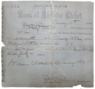
Document, Form of Register Ticket made out to William Fittall, 1862
... for the No 2 division of the Mining District of Ballaarat, have... Mining Registrar for the No 2 division of the Mining District ...Small ticket stub for a Form of Register TicketForm of Register Ticket No. 224 Schedule XXVII By Law XIII February 11th 1862 I, P.P.FitzPatrick Mining Registrar for the No 2 division of the Mining District of Ballaarat, have this eleventh day pf February 1862 registered Willia Fittall for a residence claim, 66 feet by 82 1/2 feet situated east of Peel Steeet near Black Hill Gully (signed) William Fittall on 28 January 1862sailor, immigration, thomas paterson, greenock, george dempster, chevalier -
 Bendigo Historical Society Inc.
Document - Mining leases Sandhurst 1859-1862
... in the Mining District of Sandhurst 1859-1862, (Index prepared by staff... 1936. Five page index of applications for mining leases taken ...Five page index of applications for mining leases taken out in Sandhurst, 1859-1862. Attached are print-outs of Government Gazette pages, showing entries that relate to applications for mining leases during the period 1858-1862. Slip of paper attached to front page reads: Applications for Mining Leases in the Mining District of Sandhurst 1859-1862, (Index prepared by staff at the Bendigo Goldfields Library) Note: no leases listed for Sandhurst from 1.1.1859-11.7.1859. Victorian Government Gazette, October 10, 1862, Issue 121, p 1954. Listed in index for 1862, but no leases found on that page. Phyllis Toy Collection: Government Gazette entries are described in pencil on side of Gazette page, example: Vic Govt Gazette, 13/9/1859 Issue 146, p 1936.adventure gold mine, mine leases 1858-1862, sandhurst, goldmining -
 Ararat & District Historical Society (operating the Langi Morgala Museum)
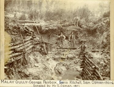
Photograph
... Shows the Ararat district's rich mining history.... the Ararat district's rich mining history. ...Shows the Ararat district's rich mining history.Black and White photo of five miners digging in a pit at Malay Gully, Mafeking. Three of the men are named George Peirbox, Serio Kitchell and Sam Osman. The sides of the pit are supported by horizontal logs.Label on front: Malay Gully, George Peirbox, Serio Kitchell, Sam Osman 1901-2 donated by Mr E Osman 1971. On back of photo: Property of E. Osman housemover and contractor ph 477 Ararat, donated by E. Osman Malay Gully Mafeking down from Browing Claim. -
 The Beechworth Burke Museum
Photograph - Photograph - Reproduction
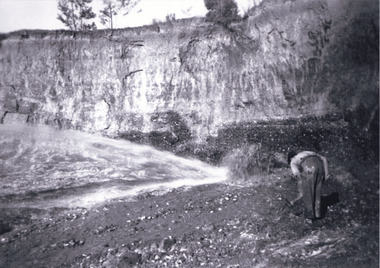
... into the Beechworth Mining District. As suggested by the numerous figures... of water races had been cut into the Beechworth Mining District ...This photograph depicts mining operations within the Beechworth area, in an unidentified valley where sluicing was utilised as a method for extracting gold from the environment. After gold was discovered in the region in 1851, sluicing became a characteristic of gold mining in the region - "Ovens miners carved intricate networks of races" throughout the region - involved the diversion of water in many channels, or water races, which contained inbuilt 'ripple devices' designed to trap gold for later extraction. By 1871, 900 miles of water races had been cut into the Beechworth Mining District. As suggested by the numerous figures involved in labouring along the water race, sluicing was a source of considerable employment within the region. This image is of important historical significance for its ability to convey information about sluicing and the methods used to find gold in the 1850s, and provides clues as to how sluicing and the widespread construction of water ranges changed the environment of the region. This image is important for current research into the history of the Ovens region in Victoria, which played such a prominent role in the early Australian gold mining industry. Therefore, this image has the capacity to be beneficial for research into society and the motivations of those living and working in this region during this period and therefore, has social significance. The Beechworth Burke Museum has additional images relating to gold sluicing and and the mining activities in the area more generally, which can be analysed and studied alongside images like this one.A black and white rectangular photograph printed on matte photographic paperbeechworth, mining, miners, labour, water race, sluicing -
 The Beechworth Burke Museum
Photograph - Photograph - Reproduction, Unknown c1852-1940
... Beechworth Mining District..., in the Beechworth Mining District established January 4th 1858 under An Act..., in the Beechworth Mining District established January 4th 1858 under An Act ...Depicted in the photograph are ten miners standing at a cliff face using a high pressure hose, in Beechworth, Victoria. The miners are located in the Three Mile Creek division, in the Beechworth Mining District established January 4th 1858 under An Act for Amending the Laws Relating to the Goldfields by the Governor-in-Council. The Ovens Gold Rush began at Beechworth in February 1852 and was followed by Yackandandah and the 'Indigo Goldfield'. The strategies applied to mining in Beechworth were distinct in comparison to other goldfields in Victoria such as Bendigo and Ballarat. The miners in Beechworth utlised 'hydraulic sluicing' to remove washdirt, the long water races and deep tailraces constructed through solid rock with an estimated 900 miles of water races cut through the Beechworth fields by 1880, demonstrating great engineering feats. The photograph taken is significant as it is a visual representation of the mining strategy, 'hydraulic sluicing' that was particularly unique to the Beechworth mines, particularly in Victoria and an engineering feat.Black and white rectangular photograph printed on matte photographic paper, unmounted print.beechworth mining district, mining, three mile creek division, three mile creek -
 Eltham District Historical Society Inc
Folder, Armstrong
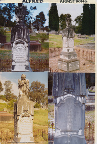
... mining district. Mrs Armstrong, to whom he was married in 1854... division of the Castlemaine mining district. Mrs Armstrong, to whom ...Alfred Armstrong Armstrong, Alfred, Eltham is a native of Somerset, England, born in 1825, and was employed under Mr. Mark Isambard Kingdom Brunel as a civil engineer prior to his coming out to Melbourne in 1852. He first visited Beechworth, but returning to Melbourne took contacts at Essendon and Gisbourne for forming and metalling the road. He afterwards purchased property at Eltham, where is at present mining, surveyor, inspector of mines, and mining registrar for the St Andrew’s division of the Castlemaine mining district. Mrs Armstrong, to whom he was married in 1854, at St Paul’s Church, Melbourne, died on 27th March, 1887. from "Victoria and its Metropolis: Past and Present" written in 1888 by Alexander Sutherland. Chapter 19, "The Upper Yarra District" pages [402] - 415. Includes descriptions of some townships and short biographies of local residents. Page 405 Folder of information on Alfred Armstrong, Eltham and Kangaroo Groundalfred armstrong, ada gertrude armstrong, arthur reynolds stockwood armstrong, arthur vivian harrison, eltham cemetery, gravestones, laura augusta harrison (nee armstrong), margaret armstrong, mary armstrong, thomas armstrong -
 Federation University Historical Collection
Book - Register, Berry Anderson & Co, Ballarat School of Mines Gold Entry Book. 1908-1976, 01/06/1908-01/12/1976
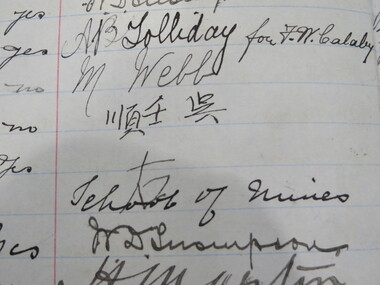
... /purchase), age, where employed, business (eg mining, fossicking...), age, where employed, business (eg mining, fossicking, assayer ...The Ballarat School of Mines had a model mine used by students, and to conduct assays for a fee. The Register of Gold Entry Book had to be kept by the Licensed Gold Buyer or Assayer under the Gold Buyers Act.Brown half leather bound register registering receipt of gold. Columns include date, nature of transaction (eg assaying/purchase), age, where employed, business (eg mining, fossicking, assayer, etc), Abode, Signature, Witness, Claim, Mining Division, District, Where Obtained, Character of Gold (eg alluvial, smelted, quartz, etc), Weight, Value, How Gold Treated, To whom delivered after assay or smelting, Date of Assayer's Certificate. ballarat school of mines, model mine, battery, assay, smelting, gold, robinson, frederick martell, r. callister, a. garrard, peter tong, lee sue, ah lung, chinese, f.w. calaby, ah kit, charlie ah lung, ah sung, ah chee, dep choon, charlie ah hing, frederick greaves, peter fong, george ah ki, ah hing, william mong, thomas bell and party, brown hill, dentist, amalgam, albert sydney sergeant, plumber, plumbing, george spence, plumber, commonwealth bank, j. hutton-jones, golden duke mining syndicate, blackwood, d.e.j. grant, eganstown, linton gold mining company, mining, d. bernard, g. peron, john page, david bernard, harry webb, ah fou, w.d. thompson, a.b. tolliday, m. webb -
Clunes Museum
Map - MAPS / DOCUMENTS
... 1859 SIGNED R. BROUGHTON, JAMES STEVENSON DISTRICT.... BROUGHTON, JAMES STEVENSON DISTRICT MINING SURVEYOR .3 40 CHAINS ....2 WAS MADE 1859.1 MAP OF CRESWICK CLUNES - 45 MINES NAMED IN CLUNES .2 DEPT. OF MINES SHOWING CLUNES - ENLARGEMENT - 100 IN CRESWICK, CRESWICK AND MCDONALD AND CO PREEMTIVE PURCHASE INDEXES OF QUARTZ AND A;LLUVIAL MINE LOCATIONS .3TOPHOGRAPHICAL MAP REF GF 23 CLUNES, MT GREENOCK TALBOT.1 360 SCALE 1 : 2500 .2 303/59 33 RECEIVED 15 OCTOBER 1859 SIGNED R. BROUGHTON, JAMES STEVENSON DISTRICT MINING SURVEYOR .3 40 CHAINS TO AN INCH mine sites, department of mines, creswick, clunes